Anti-seismic improvement
The differences between seismic improvement and seismic retro-fitting of...
Read more


November 30, 2022
The seismic classification of a territory means the division by areas of a district in question in which the seismic hazard present is identified.
More precisely, specific parameters – such as magnitude or peak acceleration – identify the areas where seismic events can occur and how much these events can cause damage to property and people.
The first attempts to implement zoning occurred at the beginning of the last century, more precisely following the Messina earthquakes of 1908, which caused 80,000 deaths, and the Avezzano earthquake of 1915, remembered as the Marsica earthquake, which caused 30,000 losses. It is precisely these events that make Italy a highly seismic area.
Given the enormous damage in terms of material assets but above all in terms of human lives, the political class intervened with the issuing of decrees which assigned the permit of seismically vulnerable municipality to the various municipalities and neighbouring areas that had been subject to seismic events.
Initially the assignment took place by proclaiming or not proclaiming a municipality to be “seismic”; later the concept of the seismic category of municipalities was divided into categories I and II, with category I being the one subject to the greater seismic risk. The design approach of the buildings was linked to the categories: the regulations defined the requirements, both at an urban level and at a technical level, for the construction details and seismic actions that should be considered.
Subsequent seismic events led to assigning the seismic hazard to an increasing number of municipalities. An example of that era, is the map that had been prepared in 1937 in which the areas that had suffered seismic events in previous years could be seen.
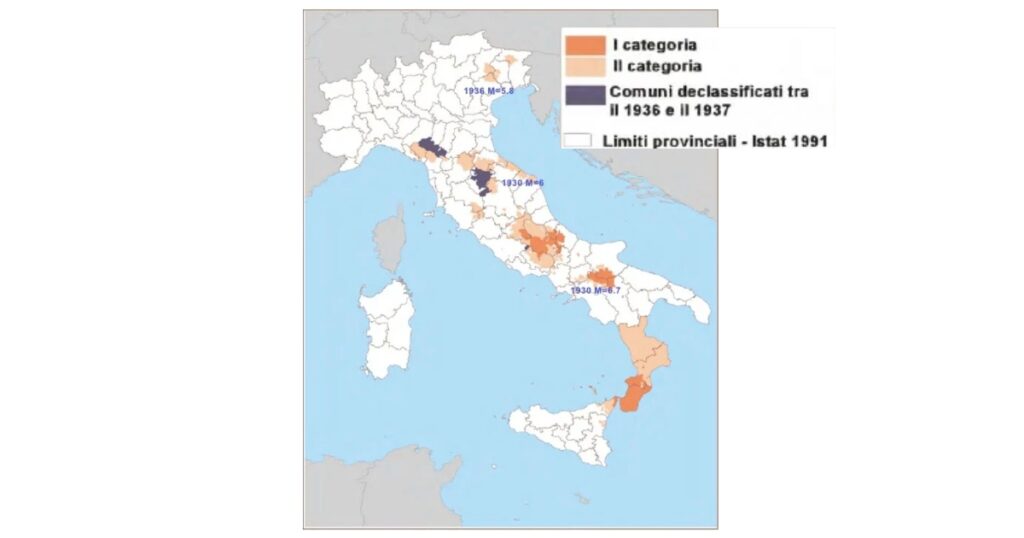
As can be seen from the map, the municipalities of much of the national territory had not been classified. In these municipalities, since there was no obligation to consider any anti-seismic requirements, buildings were not erected with the anti-seismic regulatory provisions of that time, both at an urban and technical level.
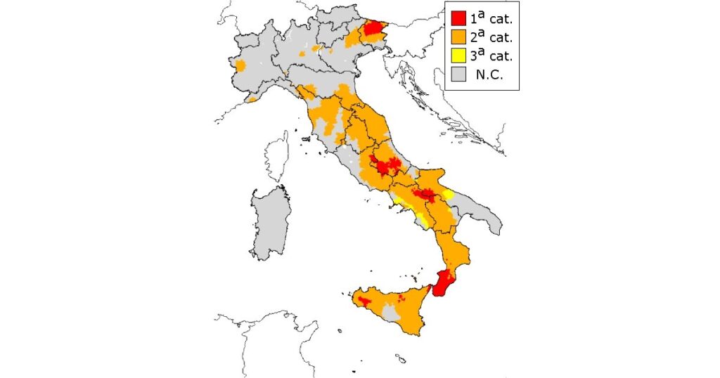
A firm point was made in 1981 when, with the entry into force of the ministerial decree, a third seismic category was introduced. At a regulatory level, focus began to shift more fully towards a dynamic mould design approach flanking the equivalent static design. The seismic grade, which could assume a value between 12, 9, or 6, linked to the first, second and third category respectively, was linked to the ratio between peak acceleration and acceleration of gravity (ag/g); however, NC defined, i.e. unclassified, zones remained present.
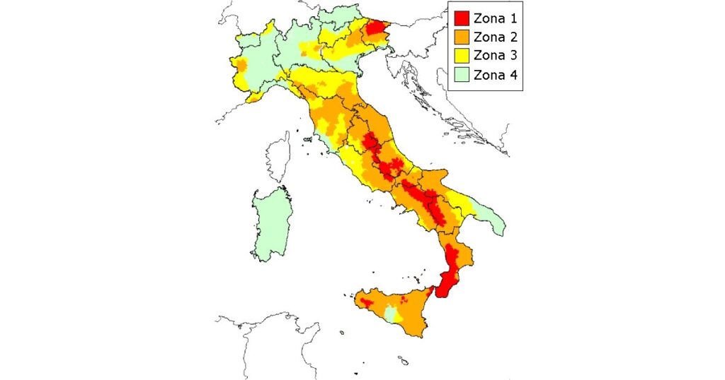
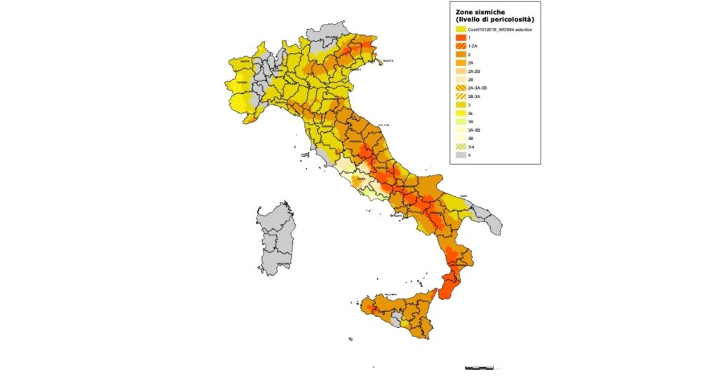
The system was truly revolutionized with OPCM 3274 of 2003. With this ordinance, the entire national territory was seismically mapped. A fourth zone was introduced and the wording of the zones was changed: from I, II III category, to identifying municipalities into zones 1 to 4, with zone 1 being the most vulnerable.
Each zone was assigned its own acceleration ag/g. For zone 1, the reference acceleration ag/g was 035, for zone 2, 0.25, for zone 3, 0.15 and for zone 4, 0.05.
Calculations were also revolutionized. The preferential approach imposed by the standard was dynamic and reflected what was reported in Eurocode 8. The regions were also given the opportunity to change the seismic zone assigned to the municipality as long as it was worse than that provided for by the ordinance. Unfortunately, in most cases this rule was not applied, as it left a loophole allowing to still design based on the old decree (Ministerial Decree 96) during the transitional phase; a phase extended until the approval of the subsequent decree. The same thing left the regions the right to decide with regard to the obligation to design with anti-seismic criteria in zone 4, something that the regions have never given.
On the positive side, however, there was the fact that the new zoning came into force, increasing the seismic zones compared to 1980 and therefore where the buildings were designed with anti-seismic dictates; the only exception remained, zones 4, as previously mentioned.
In 2005 there was the enactment of a technical standard but it never came into force, as it was superseded by subsequent standards. Nothing changed in these standards with respect to the zoning and the concepts introduced by Ordinance 3274.
Upon the issuance of the NTC of 2008 by ministerial decree, the previously established seismic zones lost their physical meaning and took on a purely administrative value. In fact, they were no longer assigned a reference acceleration, but only an indication of high or low seismic grade and their meaning was linked, above all, to the bureaucratic process of practices described in regulation 1086 of 1971 and subsequently to Presidential Decree 380.
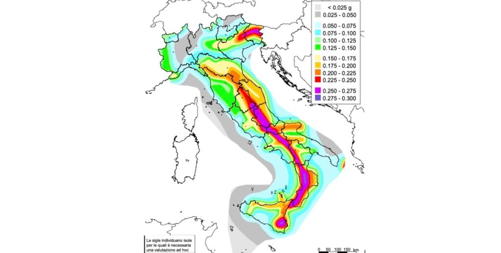
The seismic accelerations were assigned to point grid that covered the entire national territory and from which the acceleration at each point could be obtained by mediating the reference accelerations of the grid. The consequences of what was introduced by the NTC 2008 were – and are currently – the following:
The birth of two reference maps, one with physical characteristics in which the acceleration is highlighted and the other divided into four zones.
The reference accelerations are no longer just 4, so the trend from point to point is gradual and continuous, the incongruence of neighbouring municipalities with an acceleration difference of a/g =0.1 no longer exists
At a building design level, even for zone 4 there is an obligation to consider anti-seismic design. Although with the NTCs of 2008 for these areas there was still the possibility of calculation according to the MD of 96 considering a seismicity grade equal to S=5, this was completely overcome with the advent of the NTCs of 2018 where the design was made homogeneous for all areas.
To date, the situation has largely remained as established by the 2018 decree. The changes are mostly due to updating of the zones imposed by the regions which have revised the zoning at an administrative level, increasing the vulnerability of the territories and, in some cases, introducing subzones, as happened in Piedmont and Lazio.