Anti-seismic improvement
The differences between seismic improvement and seismic retro-fitting of...
Read more


April 28, 2023
This is nothing new, the events of the last few centuries have clearly shown us that Italy is a country with a significant seismic risk, variable throughout its territory, but what is that of other European States?
The researchers of SHARE have told us about a project funded by the European Union with the aim of taking a snapshot of the state of the seismic situation in Europe and its surroundings.
Thanks to the comparison of data from more than 30,000 European earthquakes with a magnitude greater than or equal to 3.5 degrees on the Richter scale since the year 1000, and considering their damage, they have produced a map that shows, in the most scientifically accurate manner possible, the seismic risk in the territories.
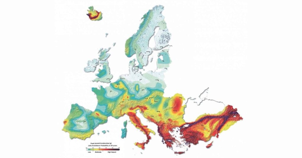
This data was obtained from the historical archive of European earthquakes (AHEAD) and subsequently cross-referenced with modern data from seismically active faults in Europe: a total of 1100 faults covering a total length of 64,000 km.
The final result was a single map (the one above) which chromatically depicts the seismic risk of the various areas where the purple/red colour represents the areas with a higher probability of potentially serious earthquakes.
The map assumes there is a 10% probability, or more, that an earthquake of the assigned seismicity level will occur within 50 years in the mapped areas.
The map identifies that the countries most exposed to potential seismic events are those in the Balkan and Mediterranean areas, obviously including Italy.
Some isolated high-risk areas are also reported, such as near Lisbon in Portugal, Brussels in Belgium, near Budapest in Hungary and along the Pyrenees mountain range.
The “hot spots” in the areas of Budapest, Lisbon and Brussels have been identified due to a frequency of past earthquakes that should not be underestimated, while the area of the Western Pyrenees is linked to the geology of the area, which hosts an active fault.
Seismic risk is not exclusively assessed by the frequency of earthquakes, but also by the extent of potential damage that could occur in a given area.
It is clear that a highly populated area risks incurring greater damage (both to structures, but above all to people) compared to a sparsely populated or uninhabited area.
Furthermore, even individual buildings within a single area can have different reactions to seismic stress depending on different characteristics, such as structural or intended use, which identify a specific seismic risk class.
For years, Seriana S.p.A. has been committed to making companies as aware as possible of the importance of seismic prevention, because, despite the high potential for an earthquake occurring in our country, there are ways to avoid being caught unprepared. Awareness and knowledge are certainly a first step.
The data highlighted by this mapping is very important in order to understand the areas where it is most necessary to act preventively, with improvement or seismic retrofitting interventions, to reduce the potential damage caused by an earthquake as much as possible.
It should also be specified that the areas highlighted as most at risk are also those with a high percentage of industrial warehouses not in step with current anti-seismic regulations, an element that is a significant part of the seismic risk calculation of an entire region.
This shows how by bringing a large number of buildings up to safety standards, the exposure level of an area can potentially be greatly reduced.